geojsonio tutorial
for v0.4.2
geojsonio converts geographic data to geojson and topojson formats. Nothing else. We hope to do this one job very well, and handle all reasonable use cases.
Functions in this package are organized first around what you’re working with or want to get, geojson or topojson, then convert to or read from various formats:
geojson_list()- convert to geojson as R list formatgeojson_json()- convert to geojson as jsongeojson_sp()- convert output ofgeojson_list()orgeojson_json()to spatial objectsgeojson_read()/topojson_read()- read a geojson/topojson file from file path or URLgeojson_write()/topojson_write()- write a geojson/topojson file locally
Each of the above functions have methods for various objects/classes, including numeric, data.frame, list, SpatialPolygons, SpatialLines, SpatialPoints, etc.
Additional functions:
map_gist()- push up a geojson or topojson file as a GitHub gist (renders as an interactive map) - See the maps with geojsonio vignette.map_leaf()- create a local interactive map with theleafletpackage - See the maps with geojsonio vignette.
Installation
Stable version from CRAN
install.packages("geojsonio")
Development version from GitHub
if (!require("devtools")) install.packages("devtools")
devtools::install_github("ropensci/geojsonio")
library("geojsonio")
GeoJSON
Convert various formats to geojson
From a numeric vector of length 2
as json
geojson_json(c(32.45, -99.74))
#> {"type":"FeatureCollection","features":[{"type":"Feature","geometry":{"type":"Point","coordinates":[32.45,-99.74]},"properties":{}}]}
as a list
geojson_list(c(32.45, -99.74))
#> $type
#> [1] "FeatureCollection"
#>
#> $features
#> $features[[1]]
#> $features[[1]]$type
#> [1] "Feature"
#>
#> $features[[1]]$geometry
#> $features[[1]]$geometry$type
...
From a data.frame
as json
library('maps')
data(us.cities)
geojson_json(us.cities[1:2, ], lat = 'lat', lon = 'long')
#> {"type":"FeatureCollection","features":[{"type":"Feature","geometry":{"type":"Point","coordinates":[-99.74,32.45]},"properties":{"name":"Abilene TX","country.etc":"TX","pop":"113888","capital":"0"}},{"type":"Feature","geometry":{"type":"Point","coordinates":[-81.52,41.08]},"properties":{"name":"Akron OH","country.etc":"OH","pop":"206634","capital":"0"}}]}
as a list
geojson_list(us.cities[1:2, ], lat = 'lat', lon = 'long')
#> $type
#> [1] "FeatureCollection"
#>
#> $features
#> $features[[1]]
#> $features[[1]]$type
#> [1] "Feature"
#>
#> $features[[1]]$geometry
#> $features[[1]]$geometry$type
...
From SpatialPolygons class
library('sp')
poly1 <- Polygons(list(Polygon(cbind(c(-100,-90,-85,-100),
  c(40,50,45,40)))), "1")
poly2 <- Polygons(list(Polygon(cbind(c(-90,-80,-75,-90),
  c(30,40,35,30)))), "2")
sp_poly <- SpatialPolygons(list(poly1, poly2), 1:2)
to json
geojson_json(sp_poly)
#> {
#> "type": "FeatureCollection",
#> "features": [
#> { "type": "Feature", "id": 1, "properties": { "dummy": 0.0 }, "geometry": { "type": "Polygon", "coordinates": [ [ [ -100.0, 40.0 ], [ -90.0, 50.0 ], [ -85.0, 45.0 ], [ -100.0, 40.0 ] ] ] } },
#> { "type": "Feature", "id": 2, "properties": { "dummy": 0.0 }, "geometry": { "type": "Polygon", "coordinates": [ [ [ -90.0, 30.0 ], [ -80.0, 40.0 ], [ -75.0, 35.0 ], [ -90.0, 30.0 ] ] ] } }
#> ]
#> }
#>
to a list
geojson_list(sp_poly)
#> $type
#> [1] "FeatureCollection"
#>
#> $features
#> $features[[1]]
#> $features[[1]]$type
#> [1] "Feature"
#>
#> $features[[1]]$id
#> [1] 1
...
From SpatialPoints class
x <- c(1, 2, 3, 4, 5)
y <- c(3, 2, 5, 1, 4)
s <- SpatialPoints(cbind(x, y))
to json
geojson_json(s)
#> {
#> "type": "FeatureCollection",
#> "features": [
#> { "type": "Feature", "id": 1, "properties": { "dat": 1 }, "geometry": { "type": "Point", "coordinates": [ 1.0, 3.0 ] } },
#> { "type": "Feature", "id": 2, "properties": { "dat": 2 }, "geometry": { "type": "Point", "coordinates": [ 2.0, 2.0 ] } },
#> { "type": "Feature", "id": 3, "properties": { "dat": 3 }, "geometry": { "type": "Point", "coordinates": [ 3.0, 5.0 ] } },
#> { "type": "Feature", "id": 4, "properties": { "dat": 4 }, "geometry": { "type": "Point", "coordinates": [ 4.0, 1.0 ] } },
#> { "type": "Feature", "id": 5, "properties": { "dat": 5 }, "geometry": { "type": "Point", "coordinates": [ 5.0, 4.0 ] } }
#> ]
#> }
#>
to a list
geojson_list(s)
#> $type
#> [1] "FeatureCollection"
#>
#> $features
#> $features[[1]]
#> $features[[1]]$type
#> [1] "Feature"
#>
#> $features[[1]]$id
#> [1] 1
...
Write geojson
library('maps')
data(us.cities)
geojson_write(us.cities[1:2, ], lat = 'lat', lon = 'long')
#> <geojson-file>
#>   Path:       myfile.geojson
#>   From class: data.frame
Read geojson
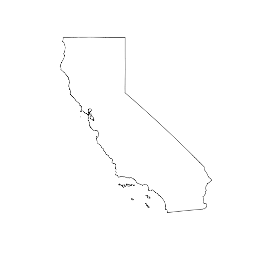
library("sp")
file <- system.file("examples", "california.geojson", package = "geojsonio")
out <- geojson_read(file, what = "sp")
plot(out)
Topojson
In the current version of this package you can read topojson. Writing topojson was in this package, but is gone for now - will come back later as in interface to topojson via V8.
Read from a file
file <- system.file("examples", "us_states.topojson", package = "geojsonio")
out <- topojson_read(file, verbose = FALSE)
summary(out)
#> Object of class SpatialPolygonsDataFrame
#> Coordinates:
#>          min       max
#> x -171.79111 -66.96466
#> y   18.91619  71.35776
#> Is projected: NA
#> proj4string : [NA]
#> Data attributes:
#>           id
#>  Alabama   : 1
#>  Alaska    : 1
#>  Arizona   : 1
#>  Arkansas  : 1
#>  California: 1
#>  Colorado  : 1
#>  (Other)   :45
Read from a URL
url <- "https://raw.githubusercontent.com/shawnbot/d3-cartogram/master/data/us-states.topojson"
out <- topojson_read(url, verbose = FALSE)
Or use as.location() first
(loc <- as.location(file))
#> <location>
#>    Type:  file
#>    Location:  /Library/Frameworks/R.framework/Versions/3.4/Resources/library/geojsonio/examples/us_states.topojson
out <- topojson_read(loc, verbose = FALSE)
Citing
Scott Chamberlain and Andy Teucher (2017). geojsonio: Convert Data from and to ‘geoJSON’ or ‘topoJSON’. R package version 0.4.2. https://cran.rstudio.com/package=geojsonio
License and bugs
- License: MIT
- Report bugs at our GitHub repo for geojsonio
